El Nino and what it means for the Americas
What is El Niño?
The full name is ENSO or El Niño Southern Oscillation, and it has two phases that act on a gradient. Both of these phases (El Niño and La Niña) are deviations from “normal” ocean conditions, or the breakdown of the climate pattern that is considered normal. These phases occur irregularly on a 2 - 7 year basis.
What is normal?
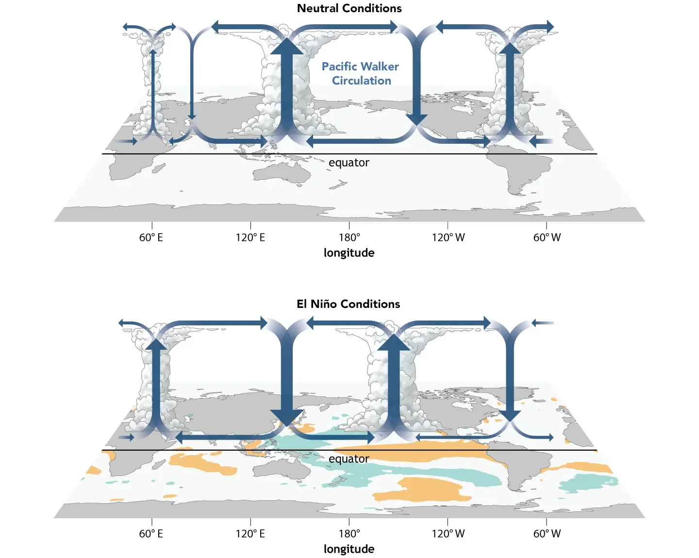
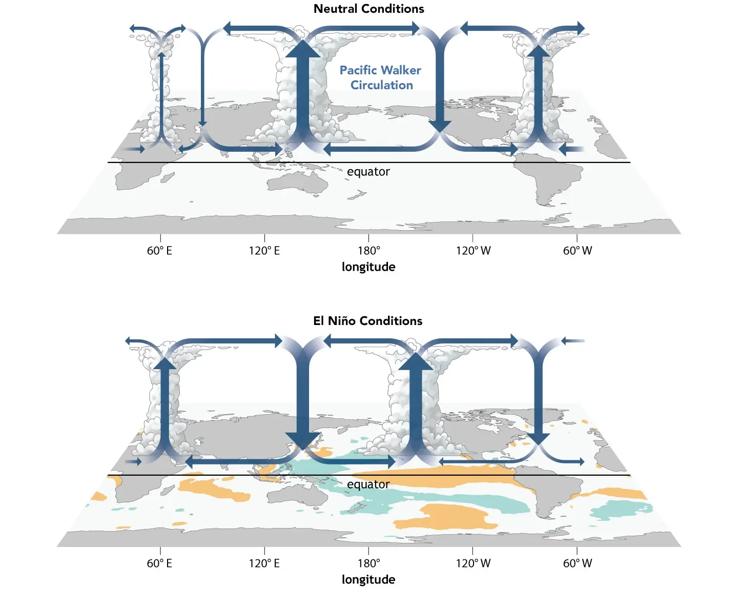
What we consider the “normal” conditions in the Pacific ocean occur when the trade winds (which act just north of the equator) continue to blow off-shore from Central America towards Asia. Trade winds carry air and warm surface water away from Central America to the middle of the Pacific Ocean. The warm surface water is replaced by cold-deep ocean water (and nutrients from the ocean floor) along the shore of the American continents. The movement of cold-nutrient rich water to the surface along the coast is called upwelling. This process supports life and productivity in the Eastern Pacific.
How does El Niño Change Normal Conditions?
El Niño conditions occur when the trade winds weaken, taking less air and warm water away from the American continents. If there is not sufficient surface water moving away, there is less cold-nutrient dense water replacing it. Therefore El Niño results in less upwelling and less productivity, leading to less food resources in the Eastern Pacific. The surface water in the Eastern Pacific will be unusually warm.
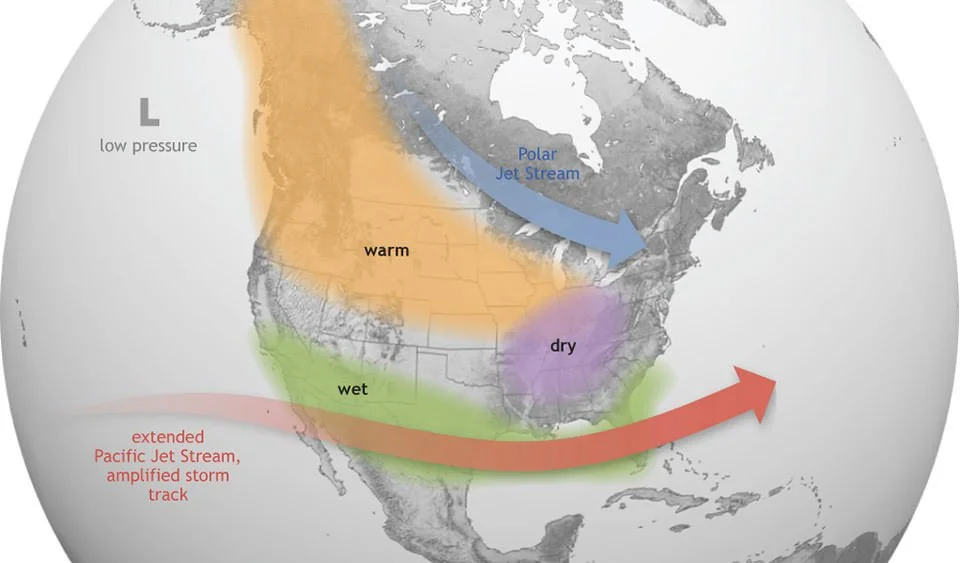
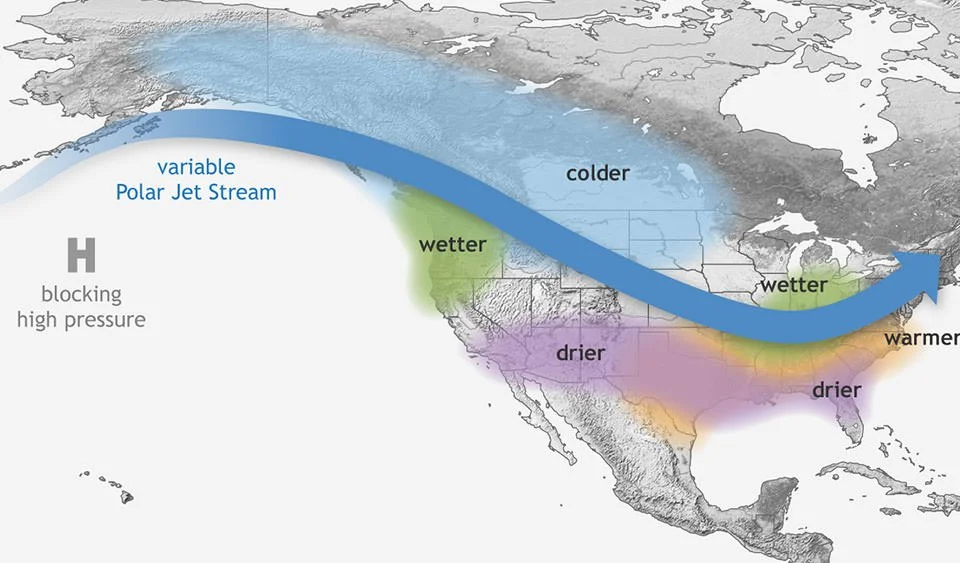
Expanding our view, the warm water that is indicative of El Niño causes the Pacific jet stream to move south which results in warmer and dryer than normal conditions in northern U.S. and Canada. In the U.S. Gulf Coast and Southeast, shifting atmospheric wind patterns causes wetter than usual and increases flooding. Despite the flooding in the southern USA, there are often fewer hurricanes in the Gulf of Mexico during El Niño years, with more hurricanes in the Pacific coast of north and central America.
How Does La Niña Alter Normal Conditions?
It follows, then, that La Niña is the opposite. During La Niña years, the trade winds are stronger than usual, which results in more movement of surface water from Central America towards Asia and increased upwelling. Increased upwelling leads to colder than normal water temperatures along the American shores and booms in oceanic productivity.
Cold water in the Eastern Pacific pushes the jet stream north leading to drought in the southern U.S. and heavy rainfall in the Pacific Northwest and Canada. La Niña winters are warmer than normal in the south and cooler than normal in the north. These conditions can all converge to result in a more severe hurricane season in the Caribbean/Gulf of Mexico (and fewer hurricanes in the Eastern Pacific).
Why are people talking about El Niño all of a sudden?
The current El Niño that is developing in the Pacific Ocean is looking (according to multiple climate models) to be the largest deviation from normal on record. It may be the arrival of something scientists predicted would come later in the century, the combination of an El Niño with the atmospheric effects of climate change.
So what does a big deviation from normal mean? It means that the ENSO effect is stronger than normal, while a normal El Niño will cause ocean temperatures to increase, a large El Niño will result in especially weak trade winds, unprecedented warming of the ocean, and complete breakdown of coastal upwelling. Places that get increased rainfall from El Niño will have even more rain and flooding, places that are dryer during El Niño will be at risk of severe drought and wildfires. These impacts can last for months and result in trillions of dollars of damage and loss of income, and loss of life from the breakdown of food supply chains and severe weather. As the effects of climate change increase, they create the perfect storm of variables to magnify El Niño effects across the globe.
The Takeaway
ENSO acts as a reminder of how interconnected our planet really is. The challenges ahead are real, but so is the power of collective adaptation. Every advancement in satellite tracking, marine management, and community disaster preparedness buys us time and saves lives. Understanding these shifts is the first step toward building stronger, more resilient coastal and agricultural communities. Nature is showing us the scale of its power and it’s up to us to match it with smart, informed, and proactive stewardship.